Transformez Documentation#
Global vertical datum transformations, simplified
Transformez Les Données
Transformez is a standalone Python engine for converting geospatial data between vertical datums (e.g., MLLW ↔ NAVD88 ↔ Ellipsoid).
Originally developed as the core transformation engine for the CUDEM project, Transformez has evolved into a standalone datum transformation suite.
Quickstart#
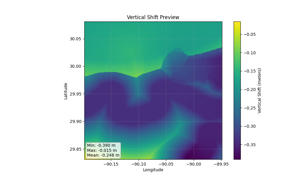 (Above: A generated vertical shift grid transforming MLLW to NAVD88)
transformez run -R loc:"new orleans" -E 3s -I mllw -O 5703
Installation#
Prerequisites: HTDP#
Transformez relies on the NGS Horizontal Time-Dependent Positioning (HTDP) software to perform highly accurate plate tectonic and frame transformations. You must install this separately.
For Windows:
Download the pre-compiled executable (
htdp.exe) directly from the NOAA HTDP page.Place
htdp.exein a directory that is in your system’sPATH(e.g.,C:\Windows\System32or a custom scripts folder).
For Linux / macOS:
You will need a Fortran compiler (like gfortran) to compile the source code.
# 1. Download the Fortran source code
wget https://geodesy.noaa.gov/TOOLS/Htdp/HTDP-download.zip
unzip HTDP-download.zip

# 2. Compile it
gfortran -o htdp htdp.f

# 3. Move it to your PATH
sudo mv htdp /usr/local/bin/
Install Transformez#
Once HTDP is accessible in your terminal, install the python package:
pip install transformez
Usage#
Generate a vertical shift grid for anywhere on Earth.
# Transform MLLW to WGS84 Ellipsoid in Norton Sound, AK

transformez grid -R -166/-164/63/64 -E 1s -I mllw -O 4979
Transform a raster directly. Transformez reads the bounds/resolution from the file.
transformez raster my_dem.tif -I mllw -O 5703
Integrate directly into your fetchez pipeline.
# Download GEBCO and shift EGM96 to WGS84 on the fly
fetchez gebco ... --hook transformez:datum_in=5773,datum_out=4979
Python API#
Transformez provides a high-level API for embedding transformations directly into your Python scripts, Jupyter Notebooks, or automated pipelines.
import transformez

# ---------------------------------------------------------
# Generate a Shift Grid
# ---------------------------------------------------------
# Returns a 2D numpy array. Optionally saves to a file.
# Requesting "mllw" in India triggers the Global Fallback (FES2014) automatically.

shift_array = transformez.generate_grid(
    region=[80, 85, 10, 15],  # [West, East, South, North]
    increment="3s",           # Grid resolution
    datum_in="mllw",
    datum_out="4979",         # WGS84 Ellipsoid
    out_fn="india_shift.tif"  # Optional: Save to disk
)

# ---------------------------------------------------------
# Transform an Existing Raster
# ---------------------------------------------------------
# Applies the datum shift directly to a DEM and saves the result.

out_file = transformez.transform_raster(
    input_raster="my_dem_mllw.tif",
    datum_in="mllw",
    datum_out="5703:g2012b",  # NAVD88 using specific GEOID12B
    output_raster="my_dem_navd88.tif"
)
Supported Datums#
🌊 Supported Tidal Surfaces:
EPSG |
NAME |
DESC |
|---|---|---|
1089 |
mllw |
[USA] |
5866 |
mllw |
[USA] |
1091 |
mlw |
[USA] |
5869 |
mhhw |
[USA] |
5868 |
mhw |
[USA] |
5714 |
msl |
[USA] |
5713 |
mtl |
[USA] |
0 |
crd |
[USA] |
5609 |
IGLD85 |
[USA] |
9000 |
LWD_IGLD85 |
[USA] |
5702 |
NGVD29 |
[GLOBAL] |
9001 |
lat |
[GLOBAL] |
9002 |
hat |
[GLOBAL] |
9003 |
mss |
[GLOBAL] |
🌐 Ellipsoidal / Frame Datums (EPSG):
EPSG |
NAME |
DESC |
|---|---|---|
4979 |
WGS84 |
World Geodetic System 1984 |
6319 |
NAD83 |
North American Datum 1983 |
🏔️ Orthometric / Geoid-Based (EPSG):
EPSG |
NAME |
DESC |
|---|---|---|
5703 |
NAVD88 height |
(Default Geoid: g2018) |
6360 |
NAVD88 height (usFt) |
(Default Geoid: g2018) |
8228 |
NAVD88 height (Ft) |
(Default Geoid: g2018) |
6641 |
PRVD02 height |
(Default Geoid: g2018) |
6642 |
VIVD09 height |
(Default Geoid: g2018) |
6647 |
CGVD2013(CGG2013) |
(Default Geoid: CGG2013) |
3855 |
EGM2008 height |
(Default Geoid: egm2008) |
5773 |
EGM96 height |
(Default Geoid: egm96) |
🌍 Available Geoids:
g2018, g2012b, geoid09, xgeoid20b, xgeoid19b, egm2008, egm96, CGG2013